The starting point is Hohnstein market square. From here, we first take the narrow Rathausstraße downhill - with the castle on our right - and then turn right onto the "Bärengarten" path. The blue line markings take us down into the Schindergraben.
The name comes from the original occupation of the "Schinder" or "Abdeckers", who gave sick animals the "Gradenstoß" and disposed of the carcasses in lonely areas - an important task for epidemic prevention.
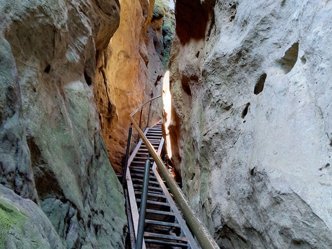
The Schindergraben flows into the Polenztal valley. After crossing the Polenz, we turn right (marked with a red dot). After a few minutes, we take the path on the left up to the Hockstein (marked with a blue and green line). This takes us through the Wolfsschlucht gorge - a very narrow and impressive crevice between the rocks. At the top we reach the Hockstein, with its rest pavilion and impressive viewpoint.
There used to be a castle on the Hockstein. The only access was a narrow crevice - the Wolfsschlucht gorge. This made the fortress easy to guard and ideal for defence in the event of an attack.
The route continues over the stone Teufelsgrundbrücke bridge. At the next crossroads, we keep left and follow the Knotenweg (green line), which later crosses a road. We continue to follow the Knotenweg (at the next crossroads without coloured path markings, turn left downhill) until we reach Koppelsgrund. Here we turn left (Füllholzelweg, red line), later cross the road again and descend into the Polenztal valley. At the bottom, we turn right and walk to the Waltersdorfer Mühle mill. Behind the mill, we cross the bridge and continue left to the Neuweg (red line). We walk uphill on this path, through the forest to the beginning of Hohnstein and then back to the starting point of the hike - the market square.


